


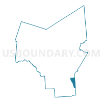
Voting District 160001, Oneida County, New York
About
Outline

Summary
| Unique Area Identifier | 633024 |
| Name | Voting District 160001 |
| County | Oneida County |
| State | New York |
| Area (square miles) | 8.37 |
| Land Area (square miles) | 8.37 |
| Water Area (square miles) | 0.01 |
| % of Land Area | 99.93 |
| % of Water Area | 0.07 |
| Latitude of the Internal Point | 42.99268850 |
| Longtitude of the Internal Point | -75.23187220 |
Maps


Graphs
Select a template below for downloading or customizing gragh for Voting District 160001, Oneida County, New York


Neighbors
Neighoring Voting District (by Name) Neighboring Voting District on the Map
- Voting District 040004, Herkimer County, NY
- Voting District 050001, Oneida County, NY
- Voting District 070001, Herkimer County, NY
- Voting District 150101, Oneida County, NY
- Voting District 150102, Oneida County, NY
- Voting District 160002, Oneida County, NY
- Voting District 160003, Oneida County, NY
- Voting District 200001, Herkimer County, NY
Top 10 Neighboring County Subdivision (by Population) Neighboring County Subdivision on the Map
- New Hartford town, Oneida County, NY (22,166)
- Frankfort town, Herkimer County, NY (7,636)
- Paris town, Oneida County, NY (4,411)
- Winfield town, Herkimer County, NY (2,086)
- Bridgewater town, Oneida County, NY (1,522)
- Litchfield town, Herkimer County, NY (1,513)
Top 10 Neighboring Place (by Population) Neighboring Place on the Map
Top 10 Neighboring Unified School District (by Population) Neighboring Unified School District on the Map
- New Hartford Central School District, NY (16,975)
- Mount Markham Central School District, NY (7,273)
- Sauquoit Valley Central School District, NY (6,700)
Top 10 Neighboring State Legislative District Lower Chamber (by Population) Neighboring State Legislative District Lower Chamber on the Map
- Assembly District 111, NY (132,613)
- Assembly District 117, NY (128,680)
- Assembly District 115, NY (127,225)
Top 10 Neighboring State Legislative District Upper Chamber (by Population) Neighboring State Legislative District Upper Chamber on the Map
- State Senate District 49, NY (296,854)
- State Senate District 51, NY (296,420)
- State Senate District 47, NY (292,134)
Top 10 Neighboring 111th Congressional District (by Population) Neighboring 111th Congressional District on the Map
Top 10 Neighboring Census Tract (by Population) Neighboring Census Tract on the Map
- Census Tract 253, Oneida County, NY (7,122)
- Census Tract 101, Herkimer County, NY (6,322)
- Census Tract 254, Oneida County, NY (5,990)
- Census Tract 255, Oneida County, NY (4,411)
- Census Tract 102.02, Herkimer County, NY (4,011)
- Census Tract 258, Oneida County, NY (1,522)